Day 2: Watton to Thetford 18 miles
- Jul 31, 2023
- 3 min read
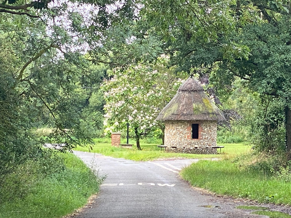
We enjoy a fabulous breakfast at The Willow House before nipping across the main road to Tesco to buy provisions and a comb. We then leave Watton behind to head for the village of Merton, with its picturesque thatched shelter on the village green. It's a small settlement hemmed in by the military land that will characterise most of our day.
We pass a field, disturbing some lapwings as we pass, and arrive at the Peddars Way. This is an old Roman road whose name is said to derive from the Latin 'pedester' meaning 'on foot'. It runs from Knettishall Heath to Holme-next-the-Sea, connecting the Icknield Way with the Norfolk Coast Path. It's typically straight and we're worried about it being boring, but have no choice as it's the only footpath here. The reason for this is soon apparent.
30,000 hectares of land in Breckland was commandeered in 1942 to form the Stanford Battle Area, now known as STANTA: the Stanford Training Area. Roads were closed and six villages were evacuated, one of them being Stanford, after which the area is now named. All that remains are the four churches (with towers). The villagers never returned, except on organised tours to visit family graves in the churchyards.

The area is marked on maps as 'Danger Area' and we soon spot the Military Firing Range Keep Out signs. Immediately, we hear gunfire and I'm very glad I'm on a national trail in peak season rather than some obscure footpath. The noises cease and I think we were just unlucky, but after that the gunfire continues all along the military area, coming from several different locations. It seems a huge amount of ordnance to be using, but maybe Monday is the main training day.
I spot a large buzzard and Rich remarks that these uninhabited military areas are a haven for wildlife. The only other creatures we find, however, are the numerous mosquitoes that flourish in the damp, dank surroundings. We eventually emerge into a more open clearing and stop for a welcome break.
We soon start off again and finally meet two other couples walking the Peddars Way. We chat with the second, who warn us about the rather malodorous poultry farm coming up, then continue on our way.
The route is becoming more broken now as we reach conurbations and approach the main railway line to Norwich and the A11. I've been hoping that being on a designated path might mean there will be crossings for these busy thoroughfares. There is a tunnel under the railway, though we ultimately decide to cross the tracks, but the dual carriageway is a free for all. The bats have bridges across the A11; humans do not. We negotiate the crossing safely enough and stop off at a roadside picnic area for lunch. A cup of tea from the kiosk is very welcome.
We spy a pair of kestrels after lunch and soon opt to take a byway to cut off a corner into Thetford. The byway is signposted, but no ordinary car could manage it, as it's just a faint track across wildflowers, including delicate harebellls. The route is unusually straight on the map, but so was the Peddars Way, so we think nothing of it.
We head into a dip and, turning a corner, find ourselves in a pig field, no trace of the byway to be found. We head up a track, skirting a field, some crops and the edge of a copse. The going is rough and we soon have several scratches to add to our insect bites. During the HoCWalk, our skin hardened up, but skin turns over rapidly and ours has long since softened. We spy some hares, deer and muntjacs, which more than compensates for our discomfort.
We turn onto another track, wondering what on earth has become of the byway, but as we reach the end, a permissive byway sign comes into view. It appears that the Ordmance Survey marking was just an approximation!

We reach a road that we follow for about four miles, seeing our last hare of the day crossing the road, and arrive on the outskirts of the town. There is a path cum cycle way that we follow until we reach Thetford Castle. From there, it is half a mile's walk to the Travelodge, our stop for the night.

Total distance: 36 miles


Comments